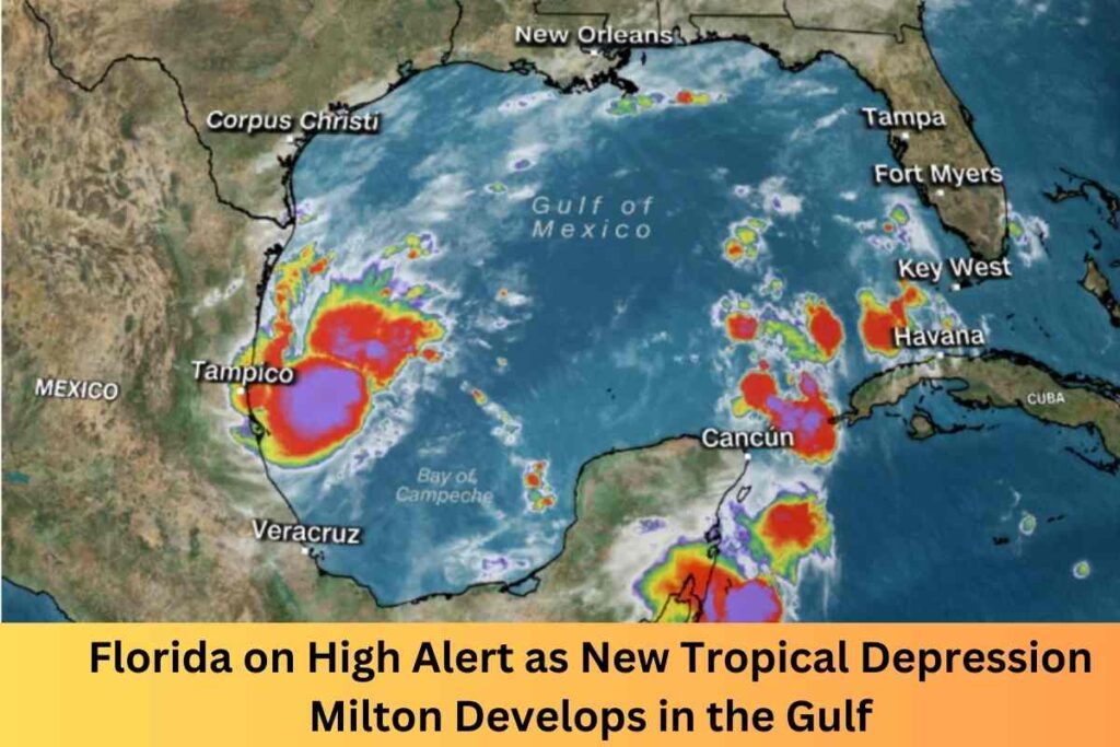
Florida on High Alert as New Tropical Depression Milton Develops in the Gulf : Less than 10 days after Hurricane Helene made a devastating impact on Florida’s Big Bend region, another storm is brewing in the Gulf of Mexico. Designated as Tropical Depression Fourteen, this system is expected to intensify into Hurricane Milton in the coming days, putting much of Florida back on high alert. With the memory of Helene’s destruction still fresh, Floridians are bracing for the possibility of another major hurricane making landfall mid-week, with forecasts indicating that Milton could bring significant winds, storm surge, and heavy rainfall.
A New Threat in the Gulf
As of Saturday morning, Tropical Depression Fourteen formed about 240 miles northeast of Veracruz, Mexico, and is currently moving slowly northeast. The storm is expected to pick up speed as it approaches Florida, reaching hurricane strength early next week. Forecasters predict that Milton could become a Category 2 or 3 hurricane by the time it nears Florida’s west coast.
Experts have expressed concern about the rapid development of this storm. Bryan Norcross, a FOX Weather Hurricane Specialist, warned that this storm could be worse than Helene for parts of the Florida coast, particularly in areas such as Fort Myers, Orlando, and Tampa.
“This one is going to develop quickly, and the impacts could be significant,” Norcross said, noting that the storm’s potential path brings life-threatening hazards for millions of residents.
Projected Impact on Florida
The National Hurricane Center (NHC) and meteorological models indicate that Hurricane Milton could bring heavy rainfall, damaging winds, and storm surges to much of Florida, particularly the western and central regions. While Milton’s exact path is still uncertain, models predict that the hardest-hit areas could see up to 8 to 12 inches of rain, with some isolated areas nearing a foot of rainfall.
Also Read : Mario Cristobal on ESPN’s College GameDay: Energizing Miami Ahead of a Crucial Matchup
Unlike Hurricane Helene, which primarily impacted the Big Bend region, Milton is expected to affect a more southern part of Florida, sparing some of the recently hit areas. Cities like Miami, Tampa, and Fort Myers are likely to see heavy rainfall, flash flooding, and coastal erosion due to rough seas and strong winds.
Florida’s Preparation and Response
State officials have already begun issuing warnings and preparing for potential evacuations in low-lying areas prone to storm surge and flooding. Emergency services are on high alert, ensuring shelters are ready, and public communication systems are in place to inform residents of any changes in the storm’s forecast. Governor Ron DeSantis urged Floridians to stay vigilant and start preparing their homes, noting that recovery from Hurricane Helene is still ongoing in some areas.
Why October Hurricanes Are a Major Concern
Historically, October is one of the most active months for hurricane activity in the Gulf of Mexico, with warm sea surface temperatures creating the perfect conditions for storm development. Data from the National Oceanic and Atmospheric Administration (NOAA) show that over 60% of hurricanes impacting Florida make landfall after the peak of the hurricane season in early September. With Milton expected to follow this trend, residents should be prepared for more potential storms as hurricane season continues into November.
Conclusion
As Florida prepares for what could be its second major hurricane in just two weeks, all eyes are on Tropical Depression Fourteen. Forecasts suggest that Hurricane Milton could be a significant and dangerous storm, with widespread impacts across the state. Floridians are urged to heed official warnings, monitor the evolving situation, and prepare for potential evacuation orders as the storm approaches.
Stay tuned to local weather channels and the National Hurricane Center for updates as the storm progresses.
Follow Us on NewUSANews Facebook Page For More Updates

