Beyond the Forecast: The Complete Guide to Understanding Summer Storms
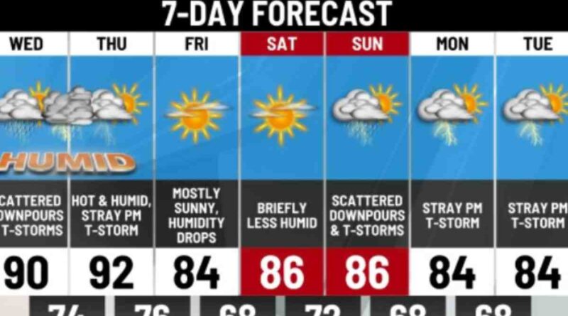
It’s a message that flickers across local news screens and buzzes on smartphones on countless summer afternoons: “More storms are developing… expect periods of heavy rain… potential for localized flash flooding through tonight.” For many, this warning is a familiar, almost routine, part of the season. It might mean canceling a barbecue, bringing in the patio furniture, or preparing for a noisy evening. But behind this simple forecast lies a story of immense power and complex atmospheric science. The journey from a calm, humid day to a torrential downpour is one of the most dynamic and fascinating processes in nature.
This post is for anyone who has ever looked at a darkening sky and wondered, “What’s really going on up there?” We will use that common local forecast as our jumping-off point to take a deep dive into the world of thunderstorms. We’ll move beyond the simple warning to explore the very anatomy of a storm: how they are born from nothing but sun, air, and moisture; the different personalities they can take on, from a brief shower to a raging supercell; and the very real dangers they carry, with a special focus on the most underestimated threat of all—flash flooding. By the end, you’ll not only understand what the meteorologist is saying, but you’ll also have a profound respect for the power of the atmosphere and the knowledge to keep you and your family safe when it unleashes its fury.
The Birth of a Storm: Nature’s Three Ingredients
A thunderstorm, for all its complexity, is born from a simple recipe that requires just three key ingredients. When these elements come together in the right way, the stage is set for an atmospheric spectacle.
Ingredient One: Moisture Storms are fundamentally about water. They need a significant source of moisture to fuel them. This is why thunderstorms are so common in humid climates and during the summer months. Warm bodies of water like the Gulf of Mexico or the Atlantic Ocean evaporate vast amounts of water into the air. This invisible water vapor, carried by winds, becomes the fuel tank for the storm. The higher the dew point—a measure of moisture in the air—the more fuel is available, leading to the potential for heavier rain.
Ingredient Two: Unstable Air (Instability) Imagine a hot air balloon. It rises because the air inside it is warmer, and therefore less dense, than the air surrounding it. The atmosphere can behave in a similar way. On a typical day, the air gets colder as you go higher. Unstable air exists when a pocket of warm, moist air near the ground is significantly warmer than the cooler, drier air above it. If this warm air gets a nudge, it will begin to rise, just like that hot air balloon. Because it’s full of moisture and remains warmer than its surroundings, it continues to accelerate upwards, creating a powerful column of rising air known as an updraft. This is the engine of the thunderstorm.
Ingredient Three: A Lifting Mechanism The warm, unstable air needs a trigger to start its upward journey. This “lift” can come from several sources. The most common is heating from the sun. As the sun warms the ground, the air directly above it warms and begins to rise. Another powerful lifting mechanism is a front—the boundary between two different air masses. A cold front, for example, acts like a wedge, aggressively forcing warm, moist air upwards. Other sources of lift can include sea breezes or air being forced up the side of a mountain. Whatever the source, this initial push is the spark that ignites the storm.
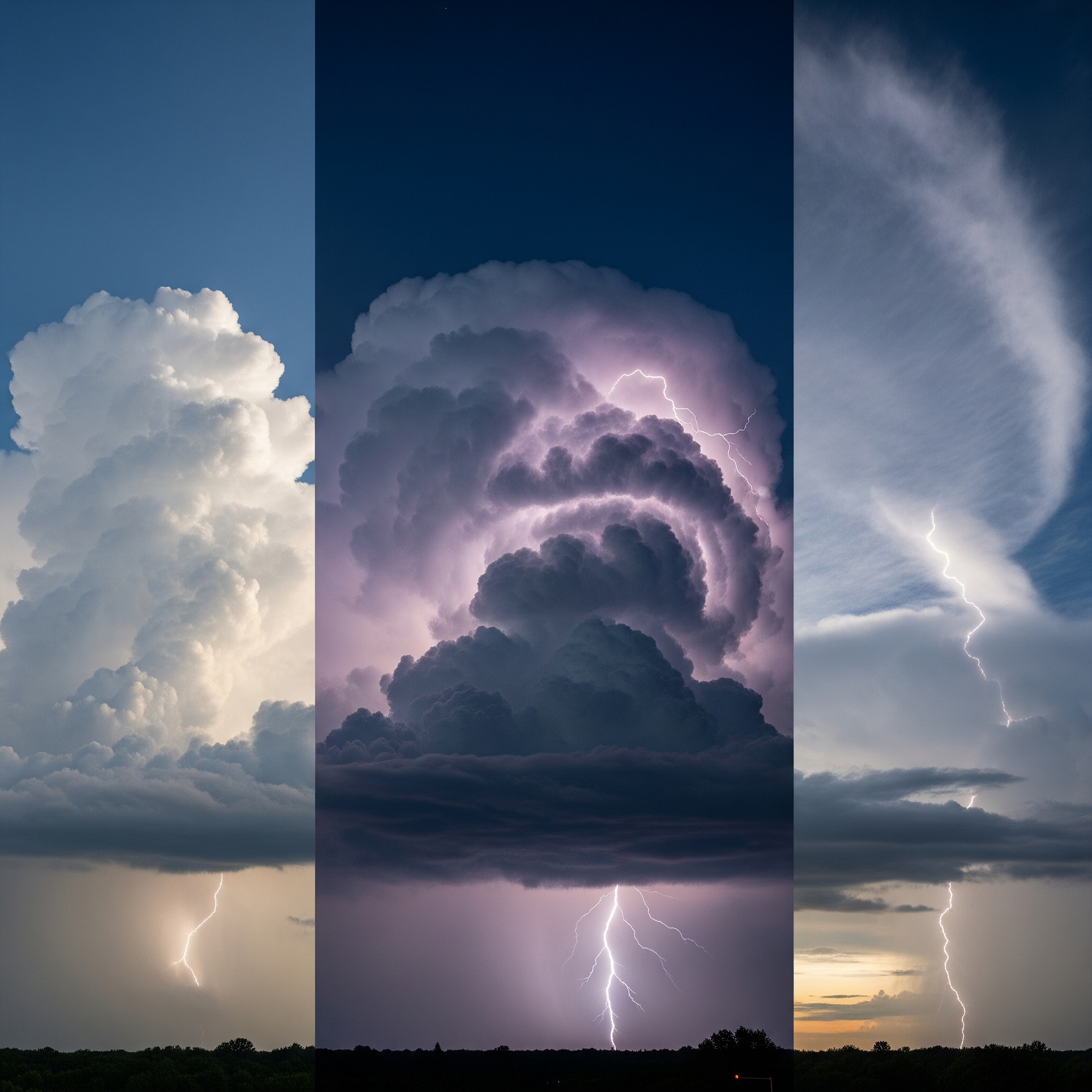
When these three ingredients combine, the developing cumulus cloud begins its rapid vertical growth. It transforms from a harmless puffy cloud into a towering, menacing cumulonimbus cloud—a thunderhead—that can stretch miles into the atmosphere.
The Life and Times of a Thunderstorm
A typical thunderstorm has a distinct life cycle, lasting from 30 minutes to over an hour. Understanding this cycle helps explain why a storm’s intensity and threats can change so rapidly.
The Developing (Cumulus) Stage This is the growth stage, dominated entirely by the updraft. Warm, moist air is drawn into the storm, rising rapidly. As it ascends into colder parts of the atmosphere, the water vapor condenses into tiny water droplets and ice crystals, releasing heat and further fueling the updraft. The cloud grows vertically, often at speeds of over 30 miles per hour. During this stage, there is no rain and typically no lightning. It’s the silent, ominous growth that precedes the storm’s arrival.
The Mature Stage This is the storm’s peak intensity and its most dangerous phase. The water droplets and ice crystals in the cloud have grown so large through collisions that the updraft can no longer hold them. They begin to fall, creating a downdraft. The mature stage is characterized by the presence of both a powerful updraft and a downdraft. The falling precipitation creates a rush of cool air that spreads out along the ground, known as a gust front—the refreshing, cool breeze you feel just before the rain starts. It is in this stage that the storm produces its most severe weather: heavy rain, frequent lightning, strong winds, and sometimes hail or tornadoes.
The Dissipating Stage Eventually, the downdraft and its cool air spread throughout the entire cloud base. This cuts off the inflow of warm, moist air—the storm’s fuel supply. With the updraft gone, the storm is dominated by the weakening downdraft. Rainfall becomes lighter and eventually stops. The storm cloud loses its sharp, defined anvil shape and begins to look more diffuse as it evaporates. The storm has run its course and dies out.
While this describes a single-cell storm, storms can also organize into much larger and more dangerous systems, like multi-cell clusters or long-lived squall lines, which can bring severe weather to a wide area for hours.
The Hidden Danger: Heavy Rain and Flash Flooding
While lightning and tornadoes often steal the headlines, the most consistent and deadly threat from the majority of thunderstorms is flash flooding. The phrase “localized heavy rain” in a forecast should never be underestimated.
What is Flash Flooding? Flash flooding is rapid flooding of low-lying areas, which can be caused by intense rainfall from a thunderstorm. Unlike river floods, which can take days to develop, flash floods can occur in just a few minutes or hours with little to no warning. This is what makes them so incredibly dangerous. A dry creek bed or an underpass can become a raging torrent of water in the blink of an eye.
Also, Read More Than a Game: Why the 2025 All-Star Game is a Battle of Baseball’s Titans
Several factors contribute to the risk. The first is rainfall rate. Some storms are incredibly efficient rain producers, dropping several inches of rain in under an hour. The second factor is the ground’s condition. If the ground is already saturated from previous rains, it can’t absorb any more water, and all new rainfall becomes immediate runoff. This is especially true in urban and suburban areas. Concrete and asphalt don’t absorb water at all. This means that in a city, rainwater is funneled directly into storm drains, which can quickly become overwhelmed, leading to rapid flooding of streets and low-lying areas.
The Terrifying Power of Water It is difficult to overstate the power of moving water. It takes just six inches of fast-moving water to knock an adult off their feet. A mere twelve inches of water is enough to float many passenger cars, and two feet of rushing water can carry away most vehicles, including SUVs and trucks. The vast majority of flash flood deaths occur when people attempt to drive through flooded roadways. This is why emergency managers and meteorologists constantly repeat the single most important piece of safety advice: Turn Around, Don’t Drown. It is never safe to drive or walk into floodwaters because you cannot know how deep the water is or if the road surface underneath has been washed away.
Understanding the Storm’s Other Weapons
Lightning: Nature’s Electricity No thunderstorm is complete without lightning. This awe-inspiring display is a massive discharge of static electricity. Within the turbulent storm cloud, ice crystals and water droplets collide, stripping electrons and creating separate regions of positive and negative charge. When this electrical imbalance becomes too great, the atmosphere breaks down, and a massive current flows to balance the charge—creating a lightning bolt. This can happen within the cloud, between clouds, or, most dangerously, between the cloud and the ground. The air around the lightning channel is heated to temperatures hotter than the surface of the sun, causing it to expand explosively. The sound wave from this expansion is what we hear as thunder. An essential safety rule: if you can hear thunder, you are close enough to be struck by lightning. The only safe place is inside a substantial building or a hard-topped vehicle.
Damaging Winds The downdraft in a mature thunderstorm can produce powerful winds. A downburst is a strong downdraft that induces an outburst of damaging winds on or near the ground. These are often mistaken for tornadoes, but the damage pattern is different (straight-line winds push debris in one direction). Microbursts are smaller, highly concentrated downbursts that can produce winds of over 100 mph, posing a significant threat to aviation and causing extensive property damage.
Staying Safe: From Watches to Warnings
Knowing how to interpret weather alerts is critical. Meteorologists use specific terms to convey the level of threat.
- Watch: A watch means that conditions are favorable for severe weather to develop in and near the watch area. It doesn’t mean severe weather is happening yet, but you should have a plan in place and stay alert. A Flash Flood Watch means be prepared to act if a warning is issued.
- Warning: A warning means that severe weather is imminent or already occurring. A Severe Thunderstorm Warning means a storm is producing winds of at least 58 mph and/or hail of at least one inch in diameter. A Flash Flood Warning means flooding is already happening or will happen soon. This is when you must take action immediately to protect your life and property.
Conclusion: Respecting the Power of the Sky
The next time you see that familiar weather alert for your area, take a moment to appreciate the incredible forces at play. A thunderstorm is one of nature’s most common yet most powerful displays. From the invisible dance of moisture and instability that gives it birth to the violent clash of updrafts and downdrafts that gives it strength, it is a marvel of atmospheric physics.
But this understanding should also breed a healthy respect. By recognizing the very real dangers of flash flooding, lightning, and wind, and by knowing the critical difference between a watch and a warning, you can move from being a passive observer to an active, prepared participant in your own safety. That simple local forecast is your first and best line of defense. Heed its warning, have a plan, and you can safely weather any storm that comes your way.
Follow Us on The NewUsaNews Facebook for more updates